
User Forums
| Forum: Tell About Great Nature/Historic Places You Like | |||||
|
|||||
|
William Henry Hyams, Ph.D.
 Posts: 78 View Profile |
Canyonlands - Needles District 2010 Posted Saturday, July 10, 2010 08:27 AM looking_back_at_island_in_sky.jpg We got up early to drive south to the Needles District of Canyonlands. We were ahead of schedule since we used the hot part of the previous day to do the Island in the Sky District - this worked out really well for us. Having seen the Island in the Sky mesa looking down, we wanted to experience getting below it to look up. So off we went down Hwy 191 to Hwy 211 to enter the park on the east side. Along Indian Creek we stopped at Newspaper Rock which has an impressive display of petroglyphs. Hwy 211 was much better than I thought it would be based on map coding. It was not long before we realized that we were in 4-wheel drive country - we were in good shape with our Hummer H3. At the visitor center we found out that we could drive close to the confluence of the Green and Colorado down a 4-wheeler road but not without risk. They said that in case we stuck the Hummer, the tow trucks would come out of Moab (and loved to get a call) where they charged by the hour from the time they left Moab. So if you needed their services, you needed 4 or 5 hundred dollars cash or a credit card with lots of room. We decided to skip on that drive adding it to my growing bucket list. I really, really, really wanted to hike the 11-mile round trip trail to the Confluence Overlook. The rangers said we should start really, really early in the morning for that hike. We settled on going to the Big Spring Canyon Overlook, the first overlook at the Slick Rock Overlook and the Cave Spring Trail. There was also a Colorado River Overlook in the same class as the Confluence Overlook. I did not add it to my bucket list. I should note that we could see the narrow mesa where we were at the Grand View Point Overlook the previous day. This is not a drive-through park cause you cannot do it! Otherwise it is. I should note that Cataract Canyon, the big whitewater place is just below the Confluence Overlook. Do not know much about it but would love to whitewater raft on the Colorado. |
||||
|
|||||
|
Wm "Billy Dick" Richmond Holly
 Joined: 09/25/09 Posts: 145 View Profile |
RE: Canyonlands - Needles District 2010 Posted Saturday, July 10, 2010 09:55 AM Hmmm, Bill I think I just decided not to follow in your footsteps, the Moki Dugway, doesn't sound like it would be a good idea pulling a travel trailer. :) A 10% grade, well, let's see that would require downshifting from 10th to probably 1st. Nah, I just don't think the average semi, loaded nor empty, would pull that. You've commented several times about "bucket lists", I think I need to add a page so that classmates can enter their bucket lists. It would be interesting to see what each of us would really like to do, even tho a lot of items would probably never come to pass for us. |
||||
|
|||||
|
William Henry Hyams, Ph.D.
Posts: 78 View Profile |
RE: Canyonlands - Needles District 2010 Posted Saturday, July 10, 2010 11:21 AM natural_bridges_0_owachomo.jpg Bill- Do not have any pictures of the Moki Dugway because Marilyn had her eyes closed and head almost in lap which is not the posture for taking pictures and I was focused on the road and I mean focused on the road. The photo is the last natural bridge in the loop - Owachomo. |
||||
|
|||||
|
William Henry Hyams, Ph.D.
Posts: 78 View Profile |
RE: Canyonlands - Needles District 2010 Posted Saturday, July 10, 2010 11:52 AM wilson_arch.jpg Bill- Stay on Hwy 191 to avoid the Moki. The photo is the Wilson Arch which we passed on the way to Needles District. |
||||
|
|||||
|
William Henry Hyams, Ph.D.
Posts: 78 View Profile |
RE: Canyonlands - Needles District 2010 Posted Sunday, July 11, 2010 08:40 AM needles_district.jpg We think such formations gave rise to the name of the district. |
||||
|
|||||
|
Wm "Billy Dick" Richmond Holly
Joined: 09/25/09 Posts: 145 View Profile |
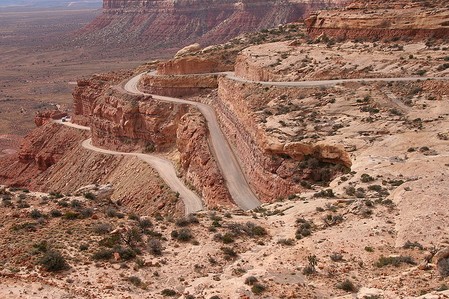
RE: Canyonlands - Needles District 2010 Posted Sunday, July 11, 2010 08:30 PM Well, Bill, taking your suggestion I looked up Moki Dugway on www.bing.com, watched the video of a truck traversing it, read of a 32' travel trailer making it, with the driver's knuckles some shade of white, and the suggestion that one carry a clean pair of shorts to change into after driving this 33 mile dirt road. Our trailer is only 27' so we may have to drive this thing one day. :) Polly is with Marilyn and says it would be better to stay off of it. :) I'm going to try to post a pic of it on here, I may have to holler at John Gongre to figure out how to do it. :) |
||||
|
|||||
|
John Monroe Gongre, Jr.
 Posts: 33 View Profile |
RE: Canyonlands - Needles District 2010 Posted Sunday, July 11, 2010 09:38 PM BILLY, I KNOW ABOUT THE WHITE KNUCKLE DRIVES. I WAS STOPPED AT THE BOTTOM OF A MOUNTAIN BEFORE THE SWITCH BACK STARTED. A MAN AND HIS WIFE, BOTH ABOUT 70+ PASSED ME IN A PICKUP PULLING A FIFTH WHEEL TRAILER. I FIGURED THAT THEY COULD DRIVE THE SWITCH BACK PULLING A TRAILER AT THIER AGE, I COULD DRIVE A CAR UP TO INDEPENDENCE PASS. SO I DROVE IT. HOWEVER, ON THE WAY UP MARGIE STARTED TELLING ME HOW CLOSE THE EDGE WAS. I TOLD HER TO KEEP QUIET. MY KNUCKLES HURT THE REST OF THE DAY. AS YOU MAY KNOW THIS IS JUST SOUTH OF LEADVILLE , CO. THIS WAS IN 2003. BY THE WAY, WHAT KIND OF CAMERA DO YOU USE?
JOHNNY |
||||
|
|||||
|
Wm "Billy Dick" Richmond Holly
Joined: 09/25/09 Posts: 145 View Profile |
RE: Canyonlands - Needles District 2010 Posted Sunday, July 11, 2010 09:48 PM Hmmm, I think you're giving me credit for taking that photo of the Moki Dugway with the switchbacks. I wish I had, but I didn't, I copied it off one of the websites describing the Moki. We just have a snapshot type digital, a Canon Power Shot A590, tho I do have a Hasselblad medium format film camera but don't use it anymore. Would like to upgrade it to digital but takes too many dollars to do so. |
||||
|
|||||
|
William Henry Hyams, Ph.D.
Posts: 78 View Profile |
RE: Canyonlands - Needles District 2010 Posted Monday, July 12, 2010 07:38 PM moki_dugway_sign.jpg Just for the record- |
||||
|
|||||
|
Wm "Billy Dick" Richmond Holly
Joined: 09/25/09 Posts: 145 View Profile |
RE: Canyonlands - Needles District 2010 Posted Monday, July 12, 2010 08:17 PM And did you notice on that sign between the "E" and the "D" of Mokee Dugway, that beautiful round emblem bearing the "Eagle, Globe and Anchor" of the United States Marine Corps? :) Semper Fi, y'all! |
||||
|
|||||